Weather Tornado Warning: How Modern Forecasting, Alerts, and Public Behavior Are Converging to Save Lives
Published: June 28, 2026
1) Introduction: What a “Weather Tornado Warning” Really Is
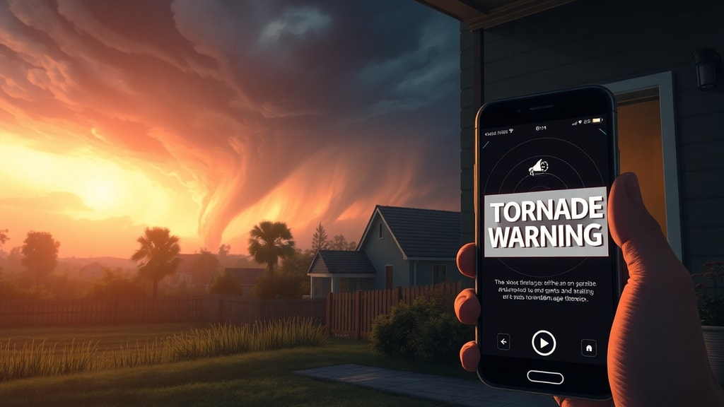
A **weather tornado warning** is an official, time-sensitive alert issued by meteorological authorities when there is a credible indication that a **tornado is likely occurring or imminently occurring** in a specific area. In the United States, this function is typically carried out by the **National Weather Service (NWS)** through local forecast offices. The message is designed for immediate public safety action—because tornadoes are among the most destructive phenomena on Earth, often striking with little warning.
To understand the warning in concrete terms, it helps to break down the phrase into its parts:
Tornado warnings are commonly accompanied by an **estimated time window** and a **geographic description** (often polygon-based in some systems, or specific county/area identifiers in others). The public is instructed to take shelter—typically in a basement or an interior room on the lowest floor, away from windows. The core premise is operational: in many cases, the warning is the best available chance to convert meteorological risk into rapid protective behavior.
What makes tornado warnings especially consequential is their dependence on a chain of events: detection of rotation or tornado signatures, rapid analysis by trained forecasters, issuance of an alert that is geographically accurate enough to guide action, and—critically—public compliance within minutes. A warning is only as effective as the entire pipeline supporting it.
2) The Catalyst: Why This Topic Is Trending Right Now
“Weather tornado warning” has become increasingly prominent in public conversation for a straightforward reason: **tornado seasons and severe-storm outbreaks are capturing sustained attention in mainstream and social media—often with real-time clips, emergency alerts, and “radar-to-phone” narratives going viral**.
Several recent patterns have intensified awareness:
1. **More frequent high-visibility events**: When widespread storm systems spawn multiple warnings across regions, the resulting sequence of alerts becomes part of everyday news consumption.
2. **Short-form video virality**: Dramatic footage—storm walls, hail, tornado debris, and emergency notifications—travels quickly. Viewers often ask why warnings arrived at the moment they did, how accurate they were, and what changed between radar signatures.
3. **Public scrutiny of alert performance**: Social channels amplify both praise and criticism. People share screenshots of phone alerts, discuss false alarms, and compare forecast confidence levels across counties and states.
4. **Technological upgrades and test campaigns**: Many jurisdictions continue to expand warning delivery—especially through Wireless Emergency Alerts, live television crawls, and smartphone integrations—making tornado warnings feel more immediate and ubiquitous.
In short, tornado warnings are trending because severe weather is being watched more closely than ever, and the warning itself has become a visible artifact of modern forecasting and emergency management.
3) Deep Dive: Historical Context and Second-Order Implications
The long arc: from “storm stories” to sensor-driven warnings
Historically, tornado warnings were constrained by what could be observed in the moment. Before today’s radar networks, the primary evidence came from **spotters, eyewitness accounts, and post-event assessments**. That reality meant warning lead times were often limited, and the geography of risk was harder to define precisely.
Radar changed the game. Today’s systems can identify storm rotation signatures and other indicators associated with tornadic development. But radar is not magic. It is a remote sensing tool that must be interpreted—its beams sample the atmosphere at certain heights, and precipitation can mask or distort what is happening. Forecasters blend radar with satellite data, model guidance, and storm reports. The decision to issue a warning is therefore both a scientific and human judgment process.
Why tornado warnings are hard—even with advanced radar
Even in the best setups, tornadic storms can be **highly localized**. A storm can be rotating strongly without producing a tornado, or a tornado can form quickly after a change in the storm’s internal dynamics. That produces two major operational tensions:
1. **Accuracy vs. lead time**: To reduce false alarms, forecasters may wait for stronger evidence. But waiting can reduce the time people have to shelter.
2. **Spatial precision vs. communication simplicity**: Defining a tight risk polygon can guide action better—but emergency messaging often must remain understandable and consistent across communities.
This is where a “second-order” effect emerges: every improvement in sensing and issuance can change how people behave. If warnings become more frequent due to heightened sensitivity, some recipients may become desensitized. If warnings become less frequent but more confident, people may take them more seriously yet lose time when the system misses brief or borderline events. The warning system is thus part meteorology, part **behavioral engineering**.
The alert chain: from radar pixels to human decisions
Consider the end-to-end pipeline:
Second-order implication: if delivery is inconsistent—say, due to phone settings, power outages, or coverage gaps—then the warning’s scientific success can still fail at the social level. Similarly, if recipients treat warnings as mere “information” rather than a call to protect themselves, then the physics of storms outpaces human response.
That is why education and drill culture matter as much as radar performance. Modern tornado-warning systems increasingly recognize that the strongest forecast is not helpful unless people are practiced, informed, and ready.
The legal and ethical layer
There is also an ethical dimension: warnings can be life-saving, but they can also impose costs—disruption, stress, and the frustration of perceived false alarms. Agencies must balance public safety against credibility. Transparent language, post-event verification, and continuous calibration of thresholds are therefore not just technical tasks; they shape public trust.
4) Future Outlook: Bob’s Forward Prediction
As Bob, I predict tornado warnings will become **both more precise and more personalized**, not by making them less urgent, but by making them more relevant to individuals and neighborhoods.
Here’s what that likely looks like in the next phase:
Most importantly, tornado warnings will remain a race against minutes. The winners—communities that reduce harm—will be those that treat warnings as part of a practiced safety system, not a last-minute surprise.
In the meteorological sense, the future is smarter detection. In the human sense, the future is preparedness.